New Experimental outlook for New England Patriots home games at Foxborough. As the Patriots host the Green Bay Packers Sunday, November 8th, skies will be clear / mostly sunny, as low pressure lifts-out behind the cold front, and high pressure building over the region, with seasonally cool temperatures (average, for time of year) in the upper 50's in Foxborough at game time. Sunday will be a good day out of the upcoming week, as a cold front will go through the region on Monday and Thursday, with cooler temperatures, possibly below normal temperatures late this week along with a possible coastal storm next weekend. The Patriots are likely to perform well with fair, seasonally cool New England weather conditions Sunday, but it may be tough against a team that can acclamate well to New England weather. GO PATRIOTS! Forecaster: Daniel Viens, establishing author of New England NAO. Thank you Cam.!
Showing posts with label Outlook. Show all posts
Saturday, November 7, 2026
NOVEMBER 8, 2026 - FOXBOROUGH, MA.
Labels:
2026,
Daniel Viens,
NAO,
New England,
November 8,
Outlook,
Patriots
Saturday, October 17, 2026
OCTOBER 18, 2026 - FOXBOROUGH, MA.
Labels:
2026,
Daniel Viens,
NAO,
New England,
October 18th,
Outlook,
Patriots
Saturday, October 10, 2026
OCTOBER 11, 2026 - FOXBOROUGH, MA.
Labels:
2026,
Daniel Viens,
NAO,
New England,
October 11th,
Outlook,
Patriots
Wednesday, November 25, 2015
WINTER SEASON 2015/16: ENTERING SOLAR MINIMUM
![]() |
| The emerging sleep of-the-Sun, with only three (3) identified sunspots visible on the solar disk as of November 25, 2015. |
Originally prepared: November 23, 2015 (Facebook timeline-post)
I would like to talk about El Niño, that has made significant headlines in the media. El Niño "The Boy", which is an unusual warming of Pacific sea surface temperature (SST) anomalies, is NOT basin wide through the equatorial Pacific Ocean. In fact close observation shows there is NO comparison to the 1997/98 super El Niño, as this particular event is *Central-to-West-based and NOT basin wide or East-based. This means the warming of SST anomalies over the Pacific is concentrated from the International Dateline, points east to the *Central / North American continent.
A *Central-to-West-based El Niño will in-fact encourage an energized sub-tropical jet-stream but ridging (above normal heights) over western North America due to the area of above normal SST's concentrated through the eastern Pacific, that will tend to encourage troughing (below normal heights) over eastern North America.
What is the foundation of the 2015/16 Winter season?
1. Solar Minimum / High Latitude Blocking - it's very important to consider that we are now entering a solar minimum following the 9-11 year sunspot cycle. The Sun has been averaging 20 daily events or less (in-terms of sunspot activity on the solar disk) since November 7, 2014, and is currently at 15 daily events as of November 20, 2015. Through the majority of absent New England Winter's of the 1990's, the Sun was averaging 40-100 daily events, * sending a moderate to high frequency of ultraviolet (UV) rays at-the-Earth. The higher frequency of ultraviolet (UV) rays acts to deplete ozone and in-return allows for pronounced cooling of the pole's stratosphere, with the Polar Vortex (PV) almost never splitting to influence middle latitudes of-the-Earth. Strongly taking into consideration current solar activity, lends hand to the highly cyclical 9-11 year (Schwabe) sunspot cycle, that we are indeed entering a solar minimum. The emerging sleep of-the-Sun will soon encourage pronounced warming of the pole's stratosphere due to increased ozone, * as this warming pushes down through the * stratosphere and troposphere, the PV will in-turn react and SPLIT, the pole will moderate. As the split PV drops south in-latitude, a reaction-to-action, ejecting the Arctic Oscillation (AO) / North Atlantic Oscillation (NAO) into a pronounced negative phase. This will be the said driver of the 500-millibar Height Pattern over the Northern Hemisphere during the coming 2015/16 Winter season, NOT El Niño.
2. El Niño - the above said factors will tend to encourage an unusually stronger than normal or *enhanced* sub-tropical jet-stream, that will as-a-result of location, be a high moisture source to interact with the Polar jet-stream. This will be, an enhancer, encouraging a moderate to strong probability of Nor'easters.
When will this change influence New England?
While we have experienced a gradual step-down since mid November, there are key signals that will indicate CHANGE.
A strong low pressure system tracking through the eastern Great Lakes region, producing rainfall in New England, around the week of November 29th may be the mechanism that encourages a significant pattern change.
Therefore, December 5-12th is the time period of high volatility.
A strong low pressure system tracking through the eastern Great Lakes region, producing rainfall in New England, around the week of November 29th may be the mechanism that encourages a significant pattern change.
Therefore, December 5-12th is the time period of high volatility.
* Corrected information on sudden stratospheric warming & the current state of El Niño.
Monday, December 23, 2013
DECEMBER 23, 2013: WHERE IS THE NAO HEADED?
![]() |
| official product of... New England NAO |
![]() |
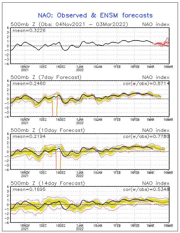
| NAO GEFS Index Forecast - December 23, 2013 |
GFS MRF Ensemble Indice Forecast from
NOAA's Climate Prediction Center (CPC) is currently weakly Positive. The GFS Ensemble Indice Forecast indicates that the NAO will be very weakly Positive December 24-27. The Ensemble Indice Forecast indicates the NAO will be neutral to very weakly Negative December 28-31. The GEFS later indicates that the NAO will trend weakly Negative January 1-7. The NAO will then trend neutral to weakly Positive January 8-15.
The NAO Operational GFS Indice Forecast from CPC is also currently weakly Positive. The GFS Indice Forecast indicates that the NAO will be very weakly Positive December 24-27. The Operational Indice Forecast indicates the NAO will be neutral to very weakly Negative December 28-31. The GFS later indicates that the NAO will trend weakly Negative January 1-7. The NAO will then trend neutral to weakly Positive January 8-15.
NOTE: Indice Forecasts have been modified, due to Forecaster's understanding of the current Longwave pattern.
![]() |
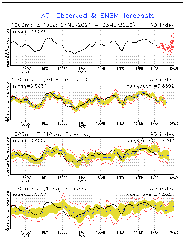
| AO GEFS Index Forecast - December 23, 2013 |
The Arctic Oscillation (AO)
GFS MRF Ensemble Indice Forecast from CPC is currently moderately Positive. The GFS Ensemble Indice Forecast indicates that the AO will be very weakly Positive December 24-27. The Ensemble Indice Forecast indicates the AO will be neutral to weakly Negative December 28-31. The GEFS later indicates that the AO will trend increasingly Negative January 1-7. The AO will then trend neutral to increasingly Positive January 8-15.
The AO Operational GFS Indice Forecast from CPC is currently moderately Positive. The GFS Indice Forecast indicates that the AO will be very weakly Positive December 24-27. The Operational Indice Forecast indicates the AO will be neutral to weakly Negative December 28-31. The GFS later indicates that the AO will trend increasingly Negative January 1-7. The AO will then trend neutral to increasingly Positive January 8-15.
NOTE: Indice Forecasts have been modified, due to Forecaster's understanding of the current Longwave pattern.
![]() |
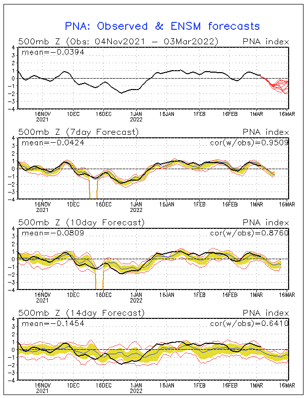
| PNA GEFS Index Forecast - December 23, 2013 |
The Pacific-North American Oscillation (PNA)
GFS MRF Ensemble Indice Forecast from CPC is currently neutral. The GFS Ensemble Indice Forecast indicates that the PNA will be neutral to very weakly Positive December 24-27. The Ensemble Indice Forecast indicates the PNA will be weakly Positive December 28-31. The GEFS later indicates that the PNA will trend increasingly Positive January 1-7. The PNA will then trend neutral to weakly Negative January 8-15.
The PNA Operational GFS Indice Forecast from CPC is currently neutral. The GFS Indice Forecast indicates that the PNA will be neutral to very weakly Positive December 24-27. The Operational Indice Forecast indicates the PNA will be weakly Positive December 28-31. The GFS later indicates that the PNA will trend increasingly Positive January 1-7. The PNA will then trend neutral to weakly Negative January 8-15.
NOTE: Indice Forecasts have been modified, due to Forecaster's understanding of the current Longwave pattern.
The Eastern Pacific Oscillation (EPO)
GFS MRF Ensemble Indice Forecast from
NOAA's Earth System Research Laboratory (Physical Sciences Division) and NCEP, is currently weakly Negative. The GFS Ensemble Indice Forecast indicates that the EPO will be weakly Negative December 24-26. This indice forecast then indicates that the EPO will be increasingly Negative December 28-31. The GEFS later indicates that the EPO will trend weakly Negative January 1-6. The EPO will then trend neutral to weakly Positive January 7-13.
GFS MRF Ensemble Indice Forecast from NOAA's ESRL/PSD and NCEP, is currently moderately Negative. The GFS Ensemble Indice Forecast indicates that the WPO will be moderately Negative December 24-26. This indice forecast then indicates that the WPO will be increasingly Negative December 28-31. The GEFS later indicates that the WPO will trend weakly Negative January 1-6. The WPO will then trend neutral to weakly Positive January 7-13.
![]() |
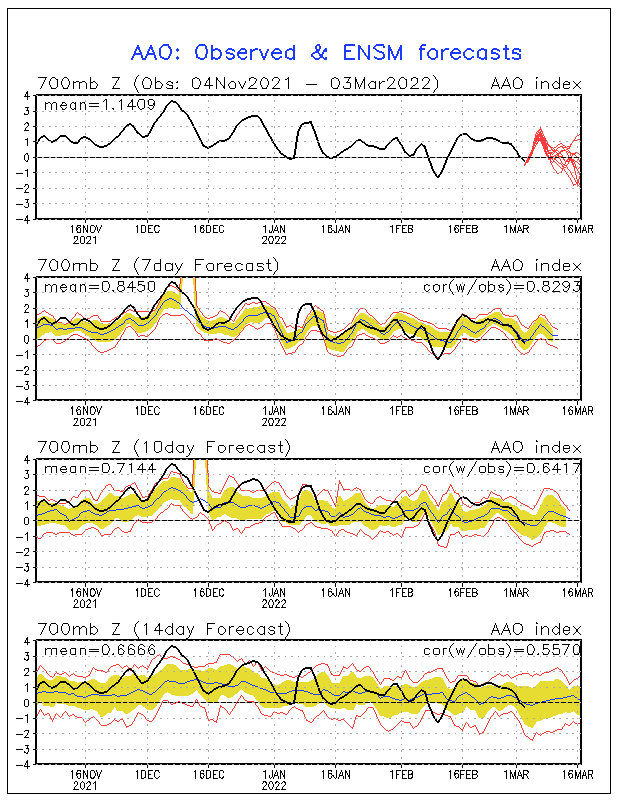
| AAO GEFS Index Forecast - December 23, 2013 |
The Antarctic Oscillation (AAO)
GFS MRF Ensemble Indice Forecast from CPC is currently neutral. The GFS Ensemble Indice Forecast indicates that the AAO will be neutral December 24-27. The Ensemble Indice Forecast indicates the AAO will be neutral to weakly Negative December 28-31. The GEFS later indicates that the AAO will trend increasingly Negative January 1-7. The AAO will then trend neutral to increasingly Positive January 8-15.
NOTE: Indice Forecasts have been modified, due to Forecaster's understanding of the current Longwave pattern.
Indice Forecasts are for Extended & Long Range Guidance only, and are not meant to be taken verbatim. Please consult NWS Albany, N. Y. / NWS Taunton, or the NWSFO covering your region... for official short-term regional zone forecasts.
| EXTENDED OUTLOOK: MERRY CHRISTMAS! |
2013/14 Winter Outlook... is well-under-way. Established High Latitude Blocking episodes appear eminent as we enter January 2014!
Updated: January 2, 2014
![]() |
| WPO GEFS Index Forecast - January 2, 2014 WHAT CAUSED THE PAST WINTER BLAST! |
As discussed in the 2013/14 Winter Outlook, it was very clear that a resurgence in Solar Activity due to increased sunspots on the magnetically active solar disk in
mid-to-late October... was responsible for the transition to an overwhelmingly
Positive Phase of the Arctic Oscillation (AO) &
North Atlantic Oscillation (NAO) from the beginning-of-November through most
all-of-December. However, there was a real Winter blast for much-of-the first half of December that led to a coastal storm on Saturday, December 14, 2013. It is very important to note that while the AO & NAO did not favor such amplification of the 500-millibar Height Pattern, the
Western Pacific Oscillation (WPO) above, and Eastern Pacific Oscillation (EPO) where predominantly Negative (circled-in-black above) from mid-to-late November through mid December. This meant that cold air was tapped and drawn southeast from North-central Canada, due to an expanding area of High pressure over the Gulf of Alaska. The WPO / EPO are highly influenced by the
Pacific Decadal Oscillation (PDO)... which became slightly Positive during the Fall, meaning that Pacific Sea Surface Temperature (SST) anomalies are warmer than normal, encouraging Blocking over the eastern Pacific.
The -WPO / -EPO pattern collapsed due to lack-of-Teleconnection support in association to changes with the Madden Julian Oscillation (MJO)... as the enhanced area of tropical convection over the equatorial Pacific entered Phase 5-6, collapsing the ridge of High pressure over the eastern Pacific, which strongly encouraged the true effects of an overwhelmingly
+AO / +NAO signature as New England experienced a classic blow-torch from December 20-23, 2013. Of interest, while the WPO & EPO where initially Positive from late October into the beginning of November... which was the peak-of-sunspot resurgence, the AO & NAO remained Positive beyond, due to extreme sensitivity to solar activity. The more active the sun, the more of a driver it is... influencing the Earth's stratosphere (poleward), where pronounced cooling occurs. Therefore, the orientation of the jet-stream keeps the heart of the Polar Vortex (PV) at the
North Pole...
encouraging an overall progressive pattern (with short-lived shots of cold air) in middle latitudes with a highly Positive Phase of the Arctic Oscillation (AO) and
North Atlantic Oscillation (NAO).
PUNCH 1! BEGINNING OF CHANGE...
![]() |
| GFS 1000-500 hPa Thickness - January 2, 2014 |
Mid-Atlantic, with a defined Polar Vortex (PV) (circled-in-white) over Quebec... marking the transition to a Negative Arctic Oscillation (AO). However, much of the southeastern United States... especially Florida, is experiencing above normal temperatures due to the North Atlantic Oscillation (NAO) only falling to around neutral. The neutral NAO allows for the southeast ridge to maintain it's identity, and in-return promotes a significant moderation for New England in-advance of Arctic fronts... due to a strong south-southwest flow in-advance of the frontal passage. This, for example, will occur on Monday, January, 6th. Aside from this, the period of January 3-10 will feature below to well below normal temperatures overall... with moderate-to-high potential of Miller Type B coastal storm development. This period will mark the true beginning of the Winter change, especially with the
Arctic Oscillation (AO).
| LONG RANGE THOUGHTS: |
THE SUN & SOLAR CYCLE 24...
![]() | ||
| NASA Solar Activity as of January 2, 2014 While Solar Activity, in-terms of active sunspots, has lessened since November 2013... the extreme western quadrant of the sun remains active. Most of the solar disk, however, is becoming quiet or falling-to-sleep... which is important for sustained High Latitude Blocking episodes, and will be a significant factor in-the-years-to-come. It is very important to remember, on January 4, 2008 we entered Solar Cycle 24. While Solar Cycle 23 was highly active in-terms of sunspot activity, Solar Cycle 24 is trending much-less-active (as seen above)... especially since the actual observed Solar Maximum in 2011/12. Had this sunspot activity took place a decade ago, the out-come on the overall 500-millibar Height Pattern in the Northern Hemisphere... would have had a far greater impact. *A note to viewers, the Fall 2013 resurgence in sunspot activity should NOT be confused with the 2011/12 Solar Maximum... as there is no comparison in the amount of UV Rays that hit the Earth now, in-contrast to then. Which is (in-part) why we will be experiencing the PUNCH-of-Winter! MJO & BRIEF THAW... PATTERN RELOAD
New England, as the AO & NAO return Positive. PUNCH 2! COMPLETE TRANSITION... |
![]() |
| NAO GFS Index Forecast - January 2, 2014 |
Sudden Stratospheric Warming (SSW) reacts, along with the continued forward propagating Phase 6-7 Madden Julian Oscillation (MJO) influence over the western Pacific, will reload the 500-millibar Height Pattern. This, however, will be a complete pattern transition... where a highly amplified -WPO / -EPO / +PNA Teleconnection, will drive a classic
-AO / -NAO couplet over eastern North America as the Polar Vortex (PV) returns to east-central Canada around January 20-22.
Prepared by: Daniel Viens
Android Smartphone users on the Google Play Market.
![]() |
What is the North Atlantic Oscillation? |
Labels:
2013,
December 23,
Forecast,
Indice,
Long Range,
Madden Julian Oscillation,
MJO,
NAO,
NE-NAO,
New England,
Outlook,
Sunspots,
Weekly Indice Review
Tuesday, November 19, 2013
THOUGHTS ON THE 2013/14 WINTER SEASON!
![]() |
| NASA Solar Activity as of November 19, 2013 |
encouraging an overall progressive pattern (with short-lived shots of cold air) in middle latitudes with a highly Positive Phase of the Arctic Oscillation (AO) and
North Atlantic Oscillation (NAO). As a result, the weather pattern experienced in middle latitudes, is an overall milder, dryer pattern... which is a signature of increased solar activity, especially during a Solar Maximum.
![]() |
| AO GEFS Index Forecast - November 19, 2013 |
![]() |
| SWPC Solar Cycle Progression as of November 4, 2013 |
on January 4, 2008 we entered Solar Cycle 24. While Solar Cycle 23 was highly active in-terms of sunspot activity, especially before the observed minimum in 2006 (as seen on the SWPC image above), Solar Cycle 24 has paled in-comparison. This is a highly important factor, that will also have a significant influence over the next decade+... considering that the actual solar cycle is about 22 years long.
My thoughts for the 2013/14 Winter Season: Due to a resurgence in solar activity, it's critical in how active the sun remains. However, I will clearly state that seeing the actual Solar Maximum was observed in 2011/12... I certainly believe that it won't be as mild as that Winter. In fact, if you follow the Schwabe Cycle closely... this resurgence in active sunspots should be short-lived. Taking this strongly into consideration, I feel the potential is strong for established High Latitude Blocking episodes from January through March. December is critical, but will more than likely be a period of transition... as the current solar activity will be less of a factor on the overall 500-millibar Height Pattern.
Now that I presented the foundation, I am going to link to NY NJ PA Weather for the finer details on the Winter Forecast for 2013/2014... which is the best seasonal outlook I have ever read.
New England NAO will continue to-be-updated through the Winter season.
Labels:
2013/14,
AO,
Blocking,
Daniel,
NAO,
New England,
Outlook,
Schwabe Cycle,
Solar Cycle 24,
Viens,
Winter
Subscribe to:
Posts (Atom)